Chicago, Illinois — Millions of Americans across the central and eastern United States could face severe thunderstorms, damaging winds and localized flooding this weekend as an active weather pattern spreads from the Plains toward the East Coast.
Forecasters say a strong jet stream interacting with warm, moisture-rich air will fuel multiple rounds of thunderstorms capable of producing dangerous weather from Thursday through Sunday.
Severe Storm Threat Builds Across the Plains
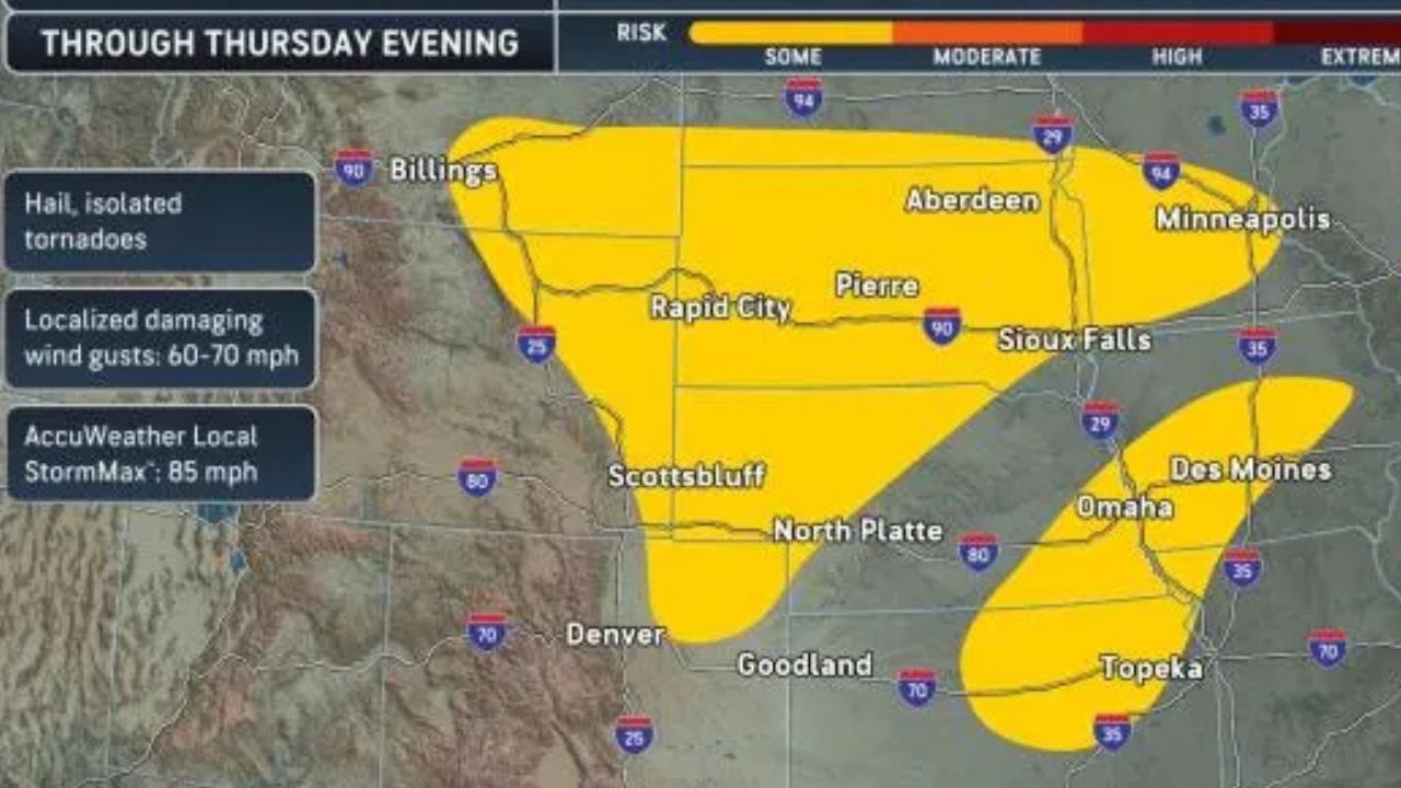
The first significant round of severe weather is expected to impact portions of the northern Plains through Thursday night.
Areas from southeastern Montana, Wyoming and northeastern Colorado to southern North Dakota and central and southwestern Minnesota face the highest threat of severe storms.
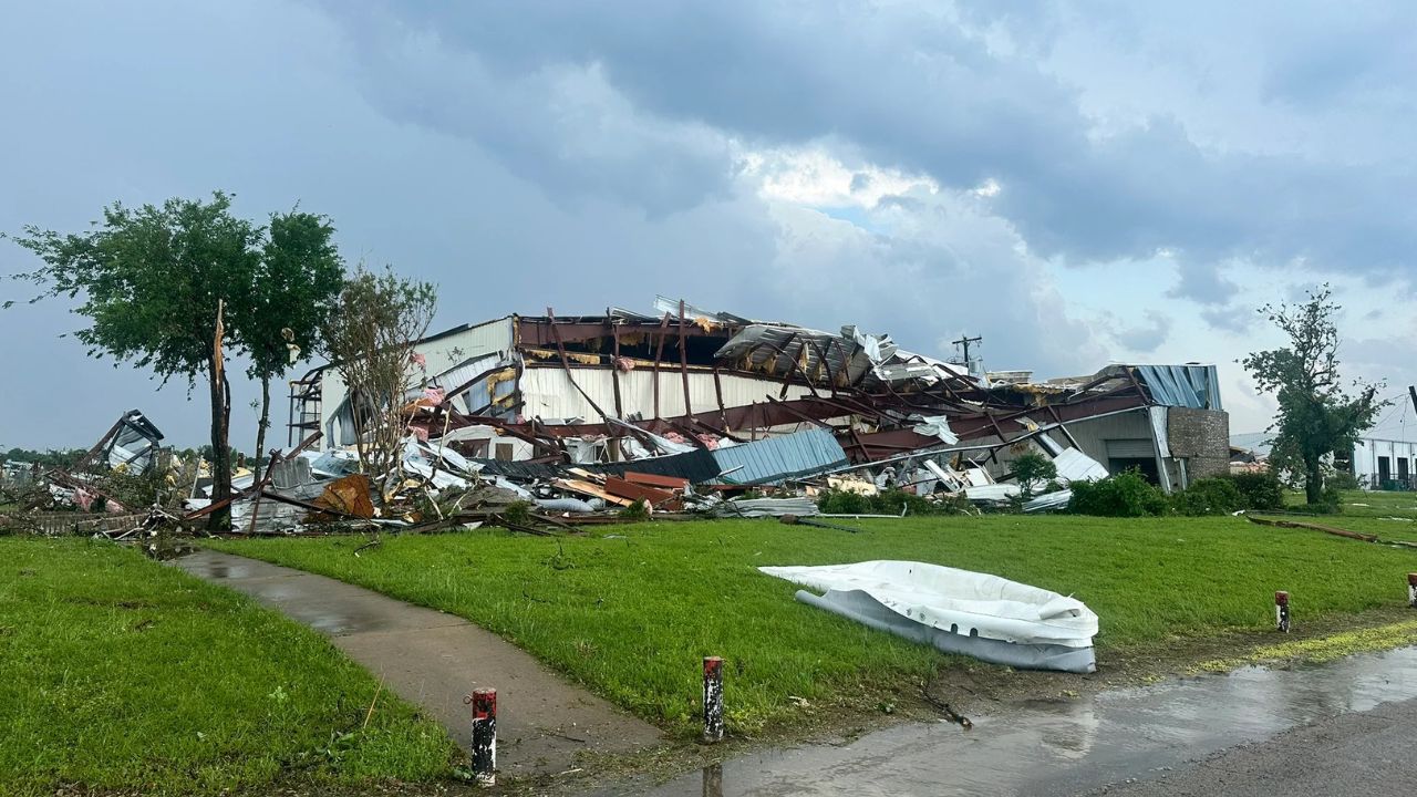
Forecasters warn that some thunderstorms could produce wind gusts up to 85 mph, large hail and even a few tornadoes. Cities including Minneapolis, Minnesota, and Pierre, South Dakota, are among the locations at risk.
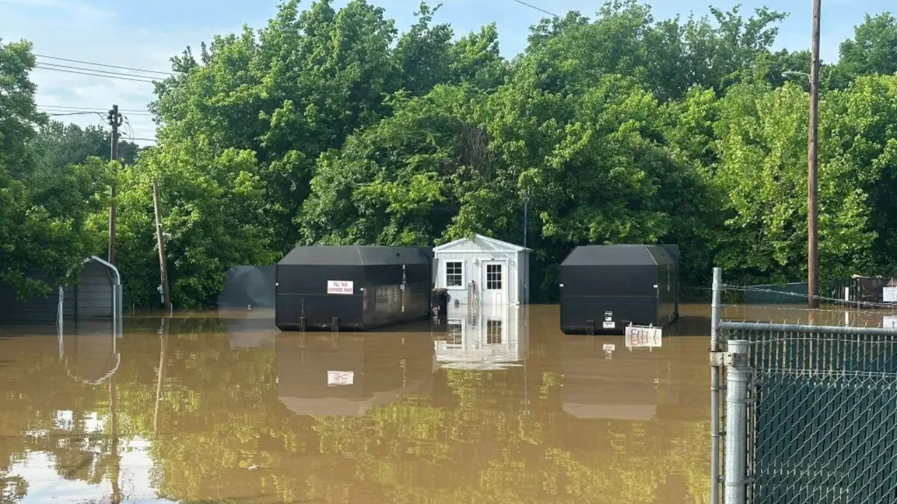
Heavy rainfall may also lead to localized flooding, particularly in urban and low-lying areas.
Friday Brings Expanding Severe Weather Risk
The severe weather threat is expected to grow on Friday as storms develop across a broader portion of the central United States.
The primary risk zone stretches from central and northern Kansas through southern Minnesota and southwestern Wisconsin. Forecasters indicate that some of the strongest storms could produce brief tornadoes, especially in parts of Iowa.
A more concentrated area of severe weather is forecast across central Iowa, where damaging winds and hail could pose the greatest threats.
Major metropolitan areas potentially affected Friday include:
- Topeka, Kansas
- Kansas City, Missouri
- Omaha, Nebraska
- Des Moines, Iowa
- Madison, Wisconsin
Residents in these areas are encouraged to remain alert for rapidly changing weather conditions throughout the afternoon and evening.
Saturday Storms Shift Toward the Midwest and Northeast
By Saturday, severe thunderstorms are expected to continue across parts of the northern Plains while a separate threat develops farther east.
The highest risk in the Plains will extend from eastern Montana and northwestern South Dakota into southeastern Saskatchewan, where damaging winds approaching 80 mph are possible.
Meanwhile, another storm corridor is expected to develop from Indiana through Pennsylvania and into upstate New York.
Forecasters say thunderstorms could stretch from northern and central Indiana through northern and western Pennsylvania into upstate New York, bringing the potential for damaging wind gusts up to 75 mph.
Isolated severe storms may also develop across portions of central New England.
The weather could potentially impact outdoor events, including activities surrounding the final leg of the Triple Crown in Saratoga Springs, New York, scheduled for Saturday evening.
Severe Weather Threat Reaches East Coast Sunday
On Sunday, the focus of severe weather is expected to shift farther south and east.
Storms capable of causing power outages, damaging winds and localized flooding are forecast from Kentucky through Delmarva and southern New Jersey.
Thousands Feel Earthquake Near Las Vegas as Magnitude 3.8 Tremor Shakes Nevada Region
Several major cities fall within the projected severe weather zone, including:
- Philadelphia, Pennsylvania
- Washington, D.C.
- Richmond, Virginia
- Charleston, West Virginia
Additional thunderstorms could extend farther north from New York City to Boston, bringing periods of heavy rain and gusty winds.
At the same time, portions of the northern and central Plains and Upper Midwest may continue to experience severe weather threats.
Safety Precautions Urged Through Weekend
Weather officials are urging anyone with outdoor plans to closely monitor forecasts and be prepared to seek shelter quickly if storms approach.
Damaging lightning, large hail, strong winds and flash flooding can occur even outside the most intense storm cells.
Drivers should never attempt to travel through flooded roadways and should reduce speed during periods of heavy rain.
Experts also emphasize that golf carts, tents and picnic pavilions do not provide protection from lightning. The safest option during a thunderstorm is to seek shelter inside a sturdy building or a hard-top vehicle.
Are you expecting severe weather in your area this weekend? Share your thoughts and preparations in the comments below.